Hindu Janajagruti Samiti (HJS) has submitted a formal memorandum to the administration requesting the reinstatement of the Maratha Empire expansion map in the NCERT Class 8 history textbook, Our Pasts–III. The request is framed as a call for historical accuracy, sound pedagogy, and transparency in the curriculum review process, rather than a mere editorial preference.
At the heart of the demand lies a straightforward pedagogical principle: historical maps anchor narrative timelines in space. For learners at the Class 8 level, cartographic visualisation makes complex political formations tangible, supports spatial reasoning, and situates key events within trade routes, ecological zones, and cultural regions. When maps that once helped students track the rise and spread of the Maratha polity are absent, the cognitive bridge between text and geography weakens, and learning outcomes can suffer.
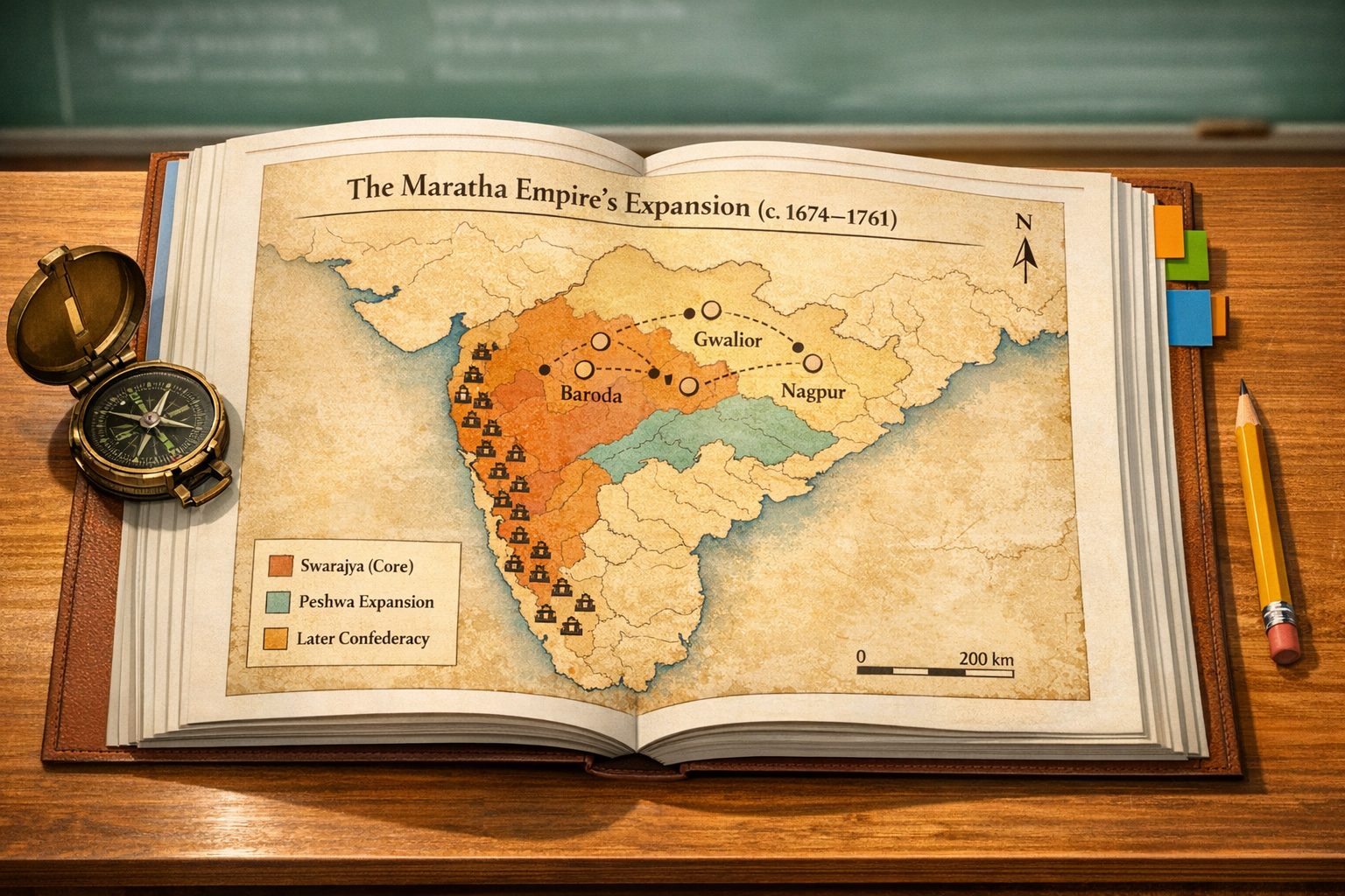
The Maratha Empire’s territorial story is a natural candidate for such visual representation. Beginning with Swarajya under Chhatrapati Shivaji Maharaj in the Konkan and the Western Ghats, and continuing through the Peshwa era (notably under Baji Rao I and his successors), Maratha influence extended across Malwa, Bundelkhand, Gujarat, parts of Odisha, and the Deccan. Confederacy-era formations under the Gaekwad of Baroda, Holkar of Indore, Scindia of Gwalior, and the Bhonsle of Nagpur demonstrate a polycentric political landscape that culminated in a pan-Indian presence before being reshaped by the aftermath of the Third Battle of Panipat (1761) and later colonial interventions.
A historically robust map for NCERT Class 8 should therefore depict core territories and expanding spheres of influence across time slices, highlight strategic forts along the Sahyadris, and indicate key corridors such as the Deccan plateau routes into Malwa. Where appropriate, it should annotate moments of inter-polity collaboration, including brief Maratha–Sikh cooperation that secured Lahore in 1758, while providing a caption that clarifies the fluidity of sovereignty, the limits of cartographic certainty, and the distinction between direct rule and suzerainty.
From a learning science perspective, reinstating the Maratha map aligns with principles of multimodal pedagogy and cognitive load theory. Visuals reduce extraneous cognitive load, allowing students to allocate more working memory to higher-order tasks such as causal analysis, comparative evaluation, and historiographical reflection. In history education research, maps have consistently been shown to strengthen schema-building by binding events, actors, and timelines to recognisable spatial frames.
There is also curricular alignment to consider. The National Curriculum Framework (NCF) 2023 emphasises inquiry-based learning, historical thinking, and the integration of Indian Knowledge Systems. A carefully annotated, age-appropriate map of Maratha expansion directly supports these competencies by inviting learners to ask how polities expand, consolidate, negotiate, and sometimes fragment, and how those processes interact with ecology, trade, and cultural patronage.
Historiographically, major scholars such as Acharya Jadunath Sarkar and R. C. Majumdar have situated the Marathas within a broader eighteenth-century transformation that included Rajputs, Jats, Sikhs, and multiple regional powers. A balanced map helps students visualise that multi-centric world without privileging any single courtly narrative. Placing the Marathas alongside contemporaneous formations, and later alongside British expansion, also fosters a comparative approach that Class 8 learners can grasp with the right scaffolding.
Equally important is the civilisational and cultural context. The Maratha polity interacted with and patronised diverse communities and institutions in a subcontinent where Hindu, Buddhist, Jain, and Sikh traditions have long coexisted and cross-pollinated. Presenting this map with a note on religious, linguistic, and mercantile diversity affirms a unifying dharmic ethosan inclusive, plural understanding of India’s cultural fabricrather than a triumphalist reading of the past.
Comparative precedent within NCERT materials also matters. Students often encounter maps of the Chola maritime reach, the Gupta heartland, or early medieval trade networks. Including a Maratha expansion map restores parity and prevents selective emphasis. Omitting it risks skewing perceptions of the eighteenth century and underplays the confederal and negotiated nature of power in the subcontinent just before colonial consolidation.
Process and policy considerations further strengthen the case for reinstatement. NCERT periodically revises content through expert committees and textbook development groups in consultation with SCERTs and subject specialists. Stakeholder memorandasuch as the one submitted by HJSare best addressed through transparent, criteria-based review: alignment with learning outcomes, fidelity to evidence, age appropriateness, and compliance with cartographic standards.
Technically, the map should use a projection and scale appropriate for a school atlas standard, with legible symbology and colour gradients to indicate phases of expansion (for example, core Swarajya, expansion under Baji Rao I, and later confederal zones). Fort icons, route arrows, and a concise legend can show logistics and strategy without visual clutter. Each visual element should be explicitly keyed to chapter sub-sections to keep text–map coherence.
Accessibility and inclusion are non-negotiable. Alt text descriptions should summarise the map for screen readers; colour choices should meet contrast guidelines; and captions should include time frames (circa 1674–1761) to help students sequence events. Such design decisions embody the Universal Design for Learning (UDL) approach increasingly promoted in Indian education discourse.
Concerns about oversimplification or politicisation can be addressed through careful framing. A clear caption can state that boundaries and spheres of influence were dynamic and contested, that multiple sourcesMarathi bakhar literature, Persian chronicles, and European recordsare synthesised with caution, and that the map is a pedagogical tool rather than a definitive geopolitical assertion.
Placing the Maratha map within the chapter on eighteenth-century political formations enables integrative learning. Students can compare administrative arrangements, revenue systems, military logistics, and diplomatic strategies across the Maratha Confederacy, regional sultanates, the Sikh misls, and the late Mughal court. This synthesis provides a richer prelude to understanding colonial-era shifts introduced later in the textbook.
In practical classroom terms, reinstatement should be coupled with reflective prompts that connect space and society: how did topography shape fort architecture in the Western Ghats; how did trade arteries across Malwa influence revenue and military provisioning; how did confederal structures distribute authority among Holkar, Scindia, Gaekwad, and Bhonsle houses. Such prompts convert a static image into a springboard for inquiry-based discussion aligned with NCERT’s competency goals.
Beyond immediate curricular gain, reinstating the Maratha Empire map contributes to a broader educational objective: cultivating historically grounded civic understanding. When learners see how alliances, negotiations, and shared institutions developed across regions and traditions, they are better able to appreciate the subcontinent’s plural heritage and the shared values that animate dharmic traditions today.
In sum, the HJS request to restore the Maratha Empire expansion map in the NCERT Class 8 textbook advances three academic priorities: fidelity to well-established historiography, adherence to evidence-based pedagogy, and commitment to inclusive, plural narratives that nurture unity. A transparent review and reinstatement, with clear annotations and accessibility features, would not only strengthen historical literacy but also help young learners perceive India’s eighteenth-century dynamism as a shared civilisational inheritance.
Inspired by this post on Hindu Jagruti Samiti.