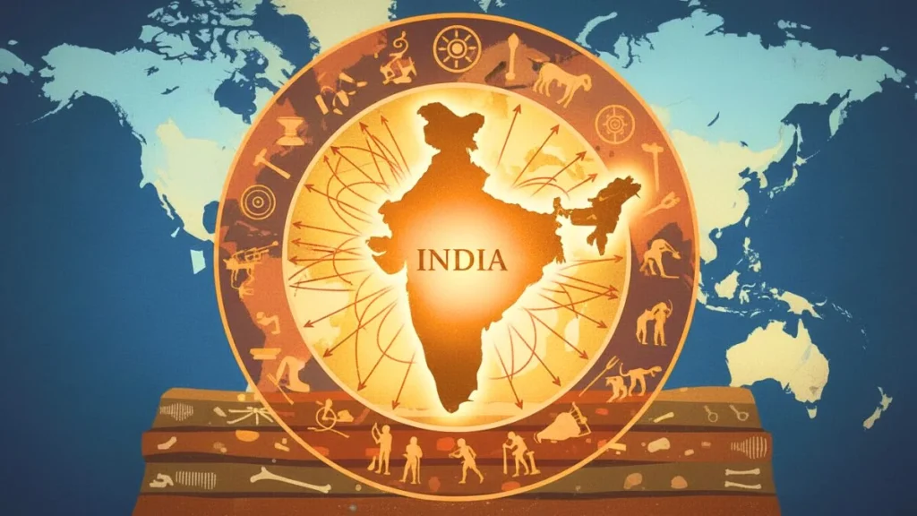
NCERT’s decision to remove a classroom map depicting the Maratha Empire’s expansion “from Attock to Cuttack” has triggered a significant debate about historical representation, pedagogy, and curricular governance in Indian textbooks. In a recent petition before the Bombay High Court, Shrimant Mudhojiraje Bhosale has challenged the change, arguing that the visual erasure diminishes a crucial chapter of Indian history and weakens students’ grasp of the subcontinent’s eighteenth-century geopolitical transformations.
Understanding the policy backdrop is essential. NCERT has undertaken textbook rationalisation across recent cycles to streamline content, reduce duplication, and align materials with the National Curriculum Framework 2023. Such revisions are typically iterative, committee-driven, and anchored in pedagogical objectives like conceptual clarity and reduced cognitive load. The removal of a single map therefore sits at the intersection of didactic priorities, historiographical judgement, and practical space constraints in schoolbooks.
Maps are not merely illustrations; they are cognitive tools that help learners anchor narrative history to spatial memory. When students see a shaded expanse or an annotated campaign route, complex sequencescampaigns, treaties, suzerainties, and reversalsacquire memorable structure. For many school communities, especially in Maharashtra and Odisha, the Attock–Cuttack arc has functioned as a shorthand for Maratha reach in the eighteenth century, often symbolising regional pride while inviting comparative reflection on contemporary frontiers and polities.
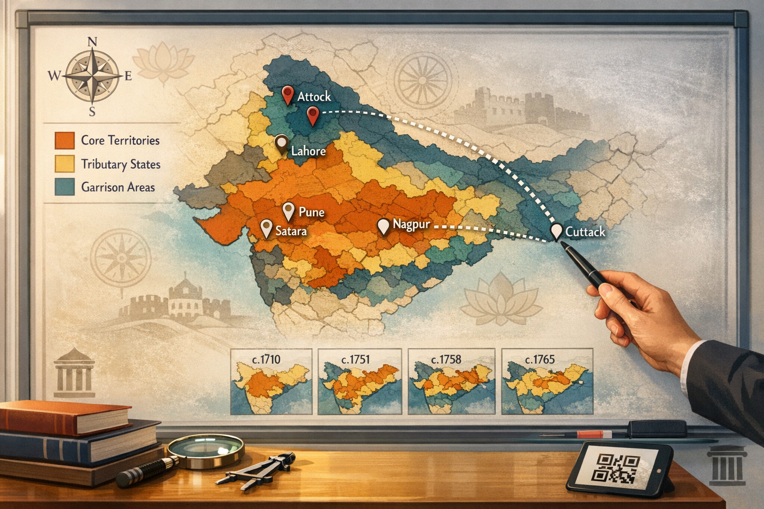
The phrase “from Attock to Cuttack” became a popular encapsulation of the Maratha sphere of operations and influence at its apogee under the Peshwas. As a historical summary, it communicates scale; as a teaching device, it invites qualification. Historians have long cautioned that such formulations conflate variable forms of authoritydirect rule, tributary suzerainty, revenue-farming rights, and short-lived garrisoninginto a single line of color on a school map. Accurately teaching this distinction is as important as the map itself.
On the northwestern frontier, Maratha forces operating in the Punjab in 1758, in concert with local Sikh groups, captured key positions including Lahore and advanced to Attock, briefly dislodging Durrani garrisons. The advance was remarkable but impermanent; Ahmad Shah Durrani’s counteroffensives and the devastating reversals of 1760–61 culminated in the Third Battle of Panipat, reshaping control across the northern plains. A textbook treatment needs to emphasize both the achievement and the volatility that followed.
On the eastern littoral, the Maratha presence in Odisha had a different character and chronology. By 1751, the Bhonsles of Nagpur had established administrative control over much of Odisha, including Cuttack, integrating the region into Maratha fiscal and military networks. This persisted until 1803, when the East India Company wrested Cuttack in the Second Anglo-Maratha War. As a classroom narrative, this eastern arc complementsrather than mirrorsthe northwestern experience, showing how expansion could be durable in one theatre and ephemeral in another.
In didactic cartography, the “Maratha Empire at its zenith” map typically generalizes these dynamics into a time-slice shading (c. mid-1750s), with dotted lines for campaigns and hatching for spheres of influence. Such generalization is didactically helpful but analytically blunt. When presented without clarifying legends and time-frames, a solid wash of color can inadvertently suggest contiguous, uniform control where the historical reality was layered and contingent.
Pedagogically, three clarifications improve accuracy without losing clarity: first, differentiating core territories from tributary and garrisoned zones; second, emphasizing the temporal dimension with inset time-series panels (e.g., c. 1710, c. 1751, c. 1758, c. 1765); and third, distinguishing fiscal rights (chauth and sardeshmukhi) from sovereign administration. These are simple cartographic conventionsline styles, hatchings, and legendsthat keep the narrative honest and the learning accessible.
Situating the map within the broader Maratha narrative also matters. From the consolidation under Chhatrapati Shivaji to the expansion under Shahu and the Peshwas (notably Baji Rao I and Balaji Baji Rao), and through the post-Panipat confederacy, learners benefit from seeing how diplomacy, cavalry mobility, revenue innovations, and regional alliances underpinned rapid advancesand how overextension, logistics, and coalition warfare constrained them. Linking the Attock–Cuttack map to these structural drivers turns a static image into a conceptual framework.
Equally important is a civilisational lens that strengthens unity among dharmic traditions. The eighteenth-century northwestern campaigns saw moments of Maratha–Sikh cooperation against common foes; in the Deccan and eastern India, Hindu, Jain, and Buddhist communities intersected with Maratha administration and commerce. Framing the period as a tapestry of interlocking dharmic communitiesrather than a zero-sum contesthelps students recognise plural participation in shaping India’s historical trajectory while nurturing interfaith respect.
Many teachers report that students vividly remember tracing the Attock–Cuttack line in class and locating Pune, Satara, Nagpur, Lahore, and Cuttack as anchor points. That tactile actpencil on paperoften becomes a first lesson in correlating political narratives with geography. Removing the visual requires compensatory strategies: annotated timelines, region-by-region case studies, and small-scale maps that preserve spatial reasoning without overwhelming younger learners.
NCERT’s publicly stated rationale for rationalisationreducing content load and overlapsdeserves careful consideration. If the Attock–Cuttack image duplicated textual explanations or appeared across grades, consolidation might be defensible. Yet where a single, well-annotated map uniquely aids comprehension, the pedagogical case for retention (or digital supplementation) is strong. Good curriculum design adjudicates these trade-offs transparently, with clear teacher guidance.
The legal question before the Bombay High Court is likely to turn on procedural reasonableness rather than historiographical preference. Courts traditionally accord autonomy to expert bodies in curricular matters, intervening where processes appear arbitrary or constitutional principles are implicated. A pragmatic judicial outcome could be a direction to constitute an expert panelincluding specialists in Indian history, school pedagogy, and cartographyto review the specific map’s didactic value and recommend a balanced remedy.
Historiography provides additional guardrails. Scholars such as R.C. Majumdar and Acharya Jadunath Sarkar long urged precision in describing eighteenth-century polities: the vocabulary of sovereignty, suzerainty, alliance, and revenue rights is not interchangeable. Presenting these distinctions equips students to appreciate the Maratha achievement without collapsing complexity, and it inoculates classrooms against both triumphalism and cynicism.
Constructively, there is no need to choose between an over-simplified map and no map at all. An updated, layered approach can combine: a compact time-series of small maps; a legend distinguishing direct rule from spheres of influence; short captions clarifying the 1758 northwestern push and the 1751–1803 Odisha arc; and a teacher’s note on the post-Panipat reconfiguration. A QR-linked digital supplement could host higher-resolution maps and primary-source excerpts to satisfy older learners without crowding the printed page.
Integrating a dharmic-pluralist perspective further strengthens cohesion. The narrative can highlight how Sikh misls, Maratha sardars, Jain financiers, and Hindu and Buddhist pilgrimage networks interacted with the eighteenth-century state. Emphasising such interdependence aligns with a pedagogical goal of unity-in-diversity, reassuring students from Hinduism, Buddhism, Jainism, and Sikhism that their shared civilisational inheritance is reflected with dignity and accuracy.
From the classroom standpoint, assessment tasks can move beyond recall. Students can compare the Attock–Cuttack configuration with later Sikh consolidation under Ranjit Singh, or contrast Maratha revenue practices in Malwa with administration in Odisha. These activities cultivate source criticism, spatial reasoning, and an appreciation for regional textures within the larger Indian story.
Potential pitfalls are well known. A monochrome “maximum extent” can invite triumphalist or defensive readings; conversely, erasing visuals can flatten understanding and dampen curiosity. Remedy lies in proportionality: retain the map with better annotations, tie it to scholarly consensus and classroom outcomes, and place it alongside comparable visuals for the Mughal, Vijayanagara, and Sikh polities to model even-handed coverage across Indian history.
In the near term, teachers in states where the map was widely used may need bridging aidslocally produced atlases, district gazetteer excerpts, or state board supplementsto preserve continuity of learning. Over the medium term, the NCERT–state board dialogue should coordinate visuals and terminology so students sitting for national assessments encounter consistent cartographic conventions.
Ultimately, the Attock–Cuttack debate is larger than a single graphic. It is about the craft of telling India’s story with fidelity, humility, and pedagogical carehonouring the Maratha Empire’s contributions within an inclusive, dharmic civilisational frame while equipping students to parse nuance. Whether through judicial guidance or expert review, a carefully annotated restoration or a robust digital companion would align curriculum policy with historical accuracy and classroom effectiveness.
Inspired by this post on Hindu Jagruti Samiti.