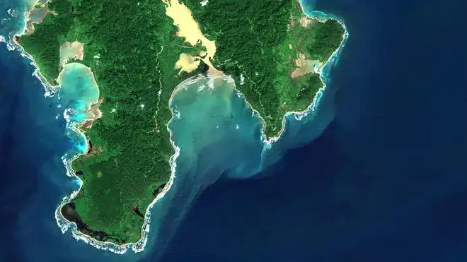
This analysis expands on “Right Word | Great Nicobar: Understanding India’s Most Strategic Infrastructure Project”, published by News18 on July 6, 2026, and places its strategic argument alongside the project’s economic, ecological, tribal and legal dimensions.
A debate too important for slogans
The Great Nicobar Holistic Development Project has become one of Bharat’s most consequential public-policy debates. Leader of the Opposition Rahul Gandhi has drawn attention to the possible loss of tropical forest, disruption of wildlife habitat and consequences for the Shompen and Nicobarese communities. The Union government, in contrast, presents the project as an essential national-security, maritime-connectivity and economic initiative. Both sets of claims concern legitimate public interests, but neither can be assessed adequately through political slogans alone.
Great Nicobar is not an interchangeable construction site. It is simultaneously a strategically placed Indian territory, a home to indigenous communities, a seismically active island and an internationally recognised biosphere reserve. Its importance creates a demanding policy test: strategic infrastructure must be evaluated rigorously, yet strategic necessity cannot function as an exemption from ecological science, tribal safeguards, financial discipline or public accountability.
The most defensible position therefore avoids a simplistic choice between national security and nature. A resilient maritime facility cannot be built by weakening the ecological systems, freshwater resources and local communities that sustain the island. Equally, ecological sensitivity does not erase the strategic significance of an Indian territory situated near some of the busiest sea lanes in the world. The appropriate question is whether the project can deliver clearly demonstrated national benefits while remaining within enforceable environmental and social limits.
What the Great Nicobar project actually includes
The official name is the “Holistic Development of Great Nicobar Island.” Great Nicobar is the southernmost island in the Andaman & Nicobar Islands, a Union Territory of Bharat. The project was conceived through the island-development process associated with NITI Aayog and is being implemented by the Andaman and Nicobar Islands Integrated Development Corporation Limited, commonly known as ANIIDCO.
A March 2025 Lok Sabha reply recorded in-principle approval from the Department of Expenditure on August 8, 2023, with a tentative cost of approximately Rs 81,000 crore over 30 years. Earlier documents used a figure near Rs 72,000 crore, while some later media reports have cited still higher estimates. The Rs 81,000-crore figure remains the clearest published whole-project baseline in the Union government’s May 2026 account, but any final investment decision should disclose an updated component-wise cost, financing structure, escalation assumption and contingency provision.
The plan brings together four interdependent assets: an International Container Transshipment Terminal at Galathea Bay, a greenfield international airport, a 450 MVA gas-and-solar power system and a new township with associated transport and utility infrastructure. These are not four isolated construction contracts. The port needs dependable electricity, aviation access, roads, communications, water, waste management and a resident workforce. The airport and township, in turn, require the economic activity and logistical demand expected from the port.
The Union government’s May 2026 background note describes a 14.2-million-TEU container terminal, an airport designed for 4,000 peak-hour passengers, a 450 MVA power plant and a township within a total planning area of 16,610 hectares, or 166.10 square kilometres. TEU means twenty-foot equivalent unit, the standard measure of container capacity. MVA measures apparent electrical power and should not be treated automatically as equivalent to megawatts without the system’s power factor and operating configuration.
Published schedules divide development into three broad stages: 72.12 square kilometres during 2025–2035, 45.27 square kilometres during 2036–2041 and 48.71 square kilometres during 2042–2047. This long horizon is strategically useful only if phasing remains genuinely conditional. Each stage should proceed after independent verification of demand, environmental compliance, tribal safeguards, disaster readiness and the performance of infrastructure already commissioned.
Why geography gives Great Nicobar exceptional strategic value
Great Nicobar lies near the western approaches to the Strait of Malacca and close to the principal east–west shipping corridor connecting the Indian and Pacific Oceans. The official project note places the proposed port approximately 40 nautical miles from the international shipping route. Galathea Bay also offers a natural water depth exceeding 20 metres, a valuable physical characteristic for accommodating large container vessels without the same degree of continuous capital dredging required at many shallower locations.
The Strait of Malacca is a critical maritime chokepoint through which a substantial share of global merchandise and energy trade moves. Ships travelling between East Asia, the Indian Ocean, the Gulf, Africa and Europe converge along this wider corridor. Great Nicobar therefore provides Bharat with geographic proximity to the commercial and strategic traffic linking two oceans.
Proximity, however, should not be confused with unilateral control. The Malacca Strait is bordered by Southeast Asian littoral states and governed by international law, navigational practice and regional diplomacy. Great Nicobar cannot by itself confer command over the strait. It can provide maritime-domain awareness, logistical reach, search-and-rescue capacity and a more persistent Indian presence near the sea lanes that affect Bharat’s trade and security.
This distinction is important. Sound strategy depends less on dramatic claims about “controlling” a chokepoint and more on practical capabilities: detecting unusual maritime activity, sharing information with partners, servicing ships and aircraft, responding to emergencies, protecting communications and sustaining operations when mainland supply chains are disrupted.
Great Nicobar also extends the southern reach of the Andaman and Nicobar island chain. Infrastructure there could complement the existing tri-service security architecture, including the naval air station at INS Baaz, without implying that every commercial asset becomes a military installation. A deep-water port, resilient airport, power system and communications network can create strategic optionality even when their routine operations are civilian.
That optionality matters during conflict, but it is equally relevant during peace. Cyclones, tsunamis, vessel accidents, oil spills and humanitarian emergencies can isolate island and coastal populations. An appropriately designed hub could support evacuation, medical assistance, disaster relief, refuelling, repair, surveillance and regional search-and-rescue operations. These public goods would strengthen Bharat’s credibility as a dependable Indo-Pacific security and humanitarian partner.
The economic logic of a transshipment hub
Transshipment occurs when containers are transferred from one vessel to another rather than being delivered directly to the port’s local hinterland. Very large “mother” ships travel between major hubs, while smaller feeder vessels connect those hubs with regional ports. A successful transshipment terminal therefore depends on location, depth, productivity, price, route deviation, shipping-line partnerships, schedule reliability and the density of feeder connections.
A portion of Indian container cargo has historically been transshipped through foreign hubs such as Colombo, Singapore and Port Klang. This creates additional handling costs and gives overseas facilities an important role in Indian supply chains. A competitive Indian hub could retain more maritime value within the country, improve schedule resilience and attract cargo from the eastern coast of Bharat, Bangladesh, Myanmar and other nearby markets.
The proposed Galathea Bay terminal has a credible locational advantage because ships would not need to make the long diversion associated with many mainland ports. The Ministry of Ports, Shipping and Waterways’ 2023 project description identified two breakwaters, a 400-metre navigational channel, an 800-metre turning circle, approximately 2.3 kilometres of berths and a 125-hectare container yard in the initial configuration. It projected roughly four million TEUs of Phase I capacity and an ultimate capacity of up to 16 million TEUs.
The difference between the 14.2-million-TEU figure in the integrated project note and the 16-million-TEU ultimate figure in port-specific publications illustrates why dates and design stages matter. Capacity numbers are not forecasts of actual traffic. They describe what infrastructure may eventually handle. Commercial success will depend on crane productivity, vessel turnaround time, tariff competitiveness, concession terms, transshipment volumes and long-term commitments from shipping alliances.
The port’s economic case should consequently be tested through transparent sensitivity analysis. Scenarios should disclose the minimum annual throughput required for viability, the effects of slower trade growth, competition from Colombo, Singapore, Port Klang and emerging Indian terminals, and the fiscal consequences if private traffic commitments do not materialise. Strategic value can justify public investment, but it should not be used to obscure commercial risk.
The airport has a similarly mixed role. Better air connectivity could reduce isolation, support emergency response and enable tourism and commerce. Public reporting has also described the airport as suitable for civil and defence requirements. Yet projections of passenger growth must account for the island’s ecological carrying capacity. Aviation demand should follow a conservation-compatible land-use plan rather than become a reason to enlarge the township or tourism footprint automatically.
The 450 MVA gas-and-solar system is intended to provide reliable power for port operations, aviation and urban services. Its design should disclose the share of solar generation, storage capacity, gas or LNG supply chain, backup requirements, lifecycle emissions and fuel-spill safeguards. Island grids are unusually vulnerable to single-point failures, so distributed solar, battery storage, protected microgrids and black-start capability may be as strategically important as total nameplate capacity.
The township is the component that requires the closest demand discipline. A port needs workers, housing and services, but a large speculative city could create environmental impacts far beyond those necessary for maritime operations. Residential, commercial, tourism and institutional construction should be tied to verified population and employment milestones. Unused urban capacity would impose ecological costs without delivering corresponding strategic or economic benefits.
An ecosystem of global and national importance
Great Nicobar cannot be assessed as vacant land awaiting productive use. In 2013, UNESCO added the Great Nicobar Biosphere Reserve to its World Network of Biosphere Reserves. UNESCO described an island dominated by tropical wet evergreen forest, supporting extensive animal diversity as well as the Shompen and Nicobarese communities. A biosphere-reserve designation does not prohibit all development, but it calls for conservation, sustainable livelihoods, scientific monitoring and participatory governance to be integrated.
The project’s terrestrial footprint intersects mature rainforest rather than a uniform plantation. Such forest stores carbon, regulates water, stabilises soil, maintains humidity and supports complex ecological relationships accumulated over long periods. Its value cannot be measured solely by counting trunks. Forest fragmentation, edge effects, road access, invasive species, artificial light and human-wildlife conflict can degrade habitat even where individual patches remain standing.
Official figures require careful interpretation. The May 2026 government note states that the broader diverted area contains an estimated 18.65 lakh trees, while a maximum of approximately 7.11 lakh trees is expected to be felled within 49.86 square kilometres. It also states that 65.99 square kilometres will remain as green zones without tree felling. Other public statements and media reports have cited figures closer to 9.64 lakh or one million trees. These differences may reflect changing designs, phases or counting methods, but they should be reconciled through a georeferenced tree and habitat inventory accessible to independent experts.
The government has proposed compensatory afforestation over 97.30 square kilometres in Haryana because suitable non-forest land is limited in the islands. This may satisfy a statutory compensatory requirement, but a new mainland plantation is not ecologically equivalent to an old tropical island forest. The two landscapes have different species, soils, hydrology and evolutionary histories. Compensatory planting should therefore supplement, not replace, the primary obligation to avoid and minimise forest loss on Great Nicobar itself.
Galathea Bay is especially sensitive because it supports nesting by giant leatherback sea turtles. Wildlife Institute of India material has identified it as one of the two important leatherback nesting areas in the Andaman and Nicobar Islands. Port construction can affect turtles through lighting, noise, dredging, changed currents, beach erosion, ship strikes and physical barriers. Safeguards must protect not only eggs and individual animals but also the beach morphology and offshore approach routes that make nesting possible.
The island also supports the Nicobar megapode, Nicobar long-tailed macaque, Nicobar tree shrew, coconut crab, saltwater crocodile and other restricted-range fauna. Linear infrastructure can interrupt movement between forest and coast. Continuous habitat corridors, limits on road width, wildlife crossings, construction-season controls and long-duration species monitoring are therefore essential components of engineering design rather than optional conservation programmes.
Marine impacts require comparable attention. Dredging and reclamation can increase turbidity, smother benthic organisms and alter sediment movement. Breakwaters can modify currents and shoreline behaviour well beyond the construction boundary. Vessel traffic introduces underwater noise, collision risk, ballast-water organisms and the possibility of fuel or chemical spills. Coral relocation may save selected colonies, but it cannot be assumed to recreate an entire reef community or its ecological functions.
Environmental management should consequently include real-time turbidity thresholds, independent bathymetric surveys, coral-health indicators, turtle-safe lighting, seasonal restrictions on disruptive marine work, vessel-speed rules, ballast-water controls and a funded oil-spill response capability. Monitoring data should be published frequently enough to permit intervention before a threshold breach becomes irreversible damage.
Freshwater is another binding constraint. High rainfall does not guarantee unlimited potable water on a small island, particularly when population, port activity and tourism expand. Environmental conditions have restricted groundwater withdrawal and withdrawal from the Galathea River. Reservoir yield, rainwater harvesting, wastewater recycling, leakage control, ecological flows and any desalination-related energy use or brine disposal must therefore be assessed as an integrated water budget.
Seismic and tsunami risk must shape every design decision
The Andaman and Nicobar Islands occupy India’s highest seismic-risk classification, Zone V, near an active plate boundary. Great Nicobar experienced the destructive consequences of the 2004 Sumatra–Andaman earthquake and Indian Ocean tsunami. Indira Point underwent roughly four metres of subsidence, illustrating that the hazard is not limited to shaking: sudden changes in land level, inundation, liquefaction, coastal erosion and loss of access can occur together.
The project’s risk assessment acknowledges earthquake and tsunami exposure. Compliance should go beyond generic claims of earthquake-resistant construction. Port structures need site-specific seismic design spectra, liquefaction analysis, tsunami inundation modelling and breakwater-failure scenarios. The township and airport require mapped evacuation routes, vertical shelters, redundant communications, protected emergency water, distributed energy and regular drills linked to the Indian tsunami early-warning system.
Resilience also requires system separation. A single corridor, substation, data link or fuel facility should not be capable of disabling the port, airport and township simultaneously. Critical assets should be elevated or protected according to hazard maps, while hospitals, command centres and shelters should retain independent power and communications. These measures add cost, but omitting them would undermine the strategic purpose of the entire investment.
Tribal protection involves more than physical relocation
Great Nicobar is home to the Shompen, classified as a Particularly Vulnerable Tribal Group, and to Nicobarese communities with deep cultural and material relationships to the island. Their forests, coasts and movement routes are not merely parcels on an administrative map. They support food, medicine, memory, kinship and cultural continuity.
The Union government’s project FAQ states that no tribal displacement will be permitted. It records 751.070 square kilometres of notified tribal reserve on Great Nicobar and says that 84.10 square kilometres of the 166.10-square-kilometre development area overlaps the reserve. According to the same account, 73.07 square kilometres would effectively be de-notified while 76.98 square kilometres would be re-notified elsewhere, producing a net addition of 3.912 square kilometres to the reserve.
A net increase in notified area is relevant, but area arithmetic cannot by itself establish that tribal interests are protected. Forest patches differ in accessibility, freshwater, food resources, sacred meaning and seasonal use. An apparently larger replacement area may not perform the same cultural or subsistence function. The quality, connectivity and community acceptance of re-notified land therefore matter as much as its size.
“No displacement” must also include protection from indirect displacement. Roads, labour camps, disease exposure, market intrusion, noise, restrictions on traditional movement and competition for natural resources can change a community’s life without moving a settlement. The Shompen’s limited contact with outsiders makes biosecurity and public-health protocols particularly important.
Tribal safeguards should include enforceable no-contact and buffer rules, culturally appropriate health surveillance, strict control of worker access, independent anthropological monitoring and protection of hunting, gathering and movement corridors. Nicobarese communities capable of direct engagement should receive accessible information, meaningful consultation, grievance mechanisms and a continuing role in decisions that affect land and livelihoods.
The government has constituted a committee to oversee Shompen and Nicobarese welfare. Its credibility will depend on independence, field presence, published non-sensitive findings and the power to require corrective action. Consultation cannot be treated as a one-time certificate obtained before construction; it must continue through design, implementation and operation.
Clearance is the beginning of accountability, not its end
Environmental clearance for the airport was granted on November 4, 2022, while the port, township and power plant received clearance on November 11, 2022. The approval contains 42 project-specific conditions in addition to standard requirements covering air, water, noise, waste, marine ecology, energy, public health, risk mitigation and disaster management. Three monitoring committees were prescribed for pollution, biodiversity and tribal welfare.
On February 16, 2026, a special bench of the National Green Tribunal declined to interfere with the environmental clearance after considering the project’s strategic importance and the work of a high-powered committee. The Tribunal nevertheless required “full and strict” compliance with the clearance conditions. Its decision means that the approval was not set aside; it does not mean that ecological damage is impossible or that subsequent non-compliance is immune from challenge.
The legal and administrative framework therefore places exceptional weight on implementation. The credibility of mitigation plans must be demonstrated through measurable results rather than their existence on paper. If a turtle beach erodes, a coral-relocation site fails, a wildlife corridor is severed or a tribal safeguard is breached, the appropriate response is not to cite the original clearance. It is to stop, investigate, redesign and remediate.
Transparency remains part of this obligation. In June 2026, political debate continued over the public availability of compliance reports, baseline studies and wildlife-mitigation plans. Legitimate security information may require protection, but ecological monitoring, forest diversion, water use, pollution data and rehabilitation measures are not automatically operational secrets. A public project of this scale benefits from a clear separation between genuinely classified material and information required for democratic and scientific scrutiny.
A rigorous framework for judging the project
First, strategic necessity should be defined precisely. Decision-makers should identify the specific capability gaps the project addresses: maritime awareness, logistics, aviation reach, transshipment resilience, disaster response or some combination of these. Clear objectives make it possible to test whether each component is necessary and whether a smaller footprint could deliver the same outcome.
Second, alternatives should be compared transparently. The relevant question is not simply whether Great Nicobar has strategic value; it plainly does. The analysis should compare port layouts, airport configurations, township scales, construction methods and the option of strengthening existing facilities. Avoidance of damage should precede mitigation, and mitigation should precede compensation.
Third, ecological limits should be expressed as enforceable thresholds. Conditions should specify acceptable turbidity, shoreline change, noise, light spill, freshwater extraction, habitat loss and species disturbance. Monitoring without predetermined response rules merely records deterioration. Stop-work triggers and restoration obligations must be defined before construction reaches sensitive areas.
Fourth, tribal welfare should be measured through lived outcomes. Indicators should cover health, access to traditional territory, food security, cultural continuity, voluntary engagement and exposure to outsiders. A paper increase in reserve area cannot substitute for evidence that communities remain secure and autonomous.
Fifth, disaster resilience should be independently certified. Seismic, tsunami, cyclone and climate risks must be integrated into location, elevation, structure, evacuation and redundancy decisions. Safety reviews should be repeated as scientific models, sea levels and construction plans change.
Sixth, commercial and fiscal performance should be stage-gated. Port expansion should respond to contracted or demonstrated traffic rather than aspirational capacity. Township and airport expansion should follow verified population and passenger demand. Public reporting should distinguish sunk cost, committed cost, private investment, contingent liability and operating subsidy.
Seventh, monitoring should be institutionally independent. Satellite imagery, biodiversity surveys, water-quality measurements and financial milestones should be published through a time-stamped dashboard. Universities, specialist institutions and community representatives should be able to review data. Independent verification would strengthen the project against both unsubstantiated criticism and unsubstantiated official assurance.
The strategic conclusion
Great Nicobar’s strategic rationale is substantial. Its location near the east–west shipping corridor can improve Bharat’s maritime awareness, logistics, supply-chain resilience and capacity to provide humanitarian assistance across the Indo-Pacific. A competitive deep-water transshipment terminal could also reduce dependence on foreign hubs and create a new maritime economic node.
Those benefits are not automatic. A port can possess excellent geography and still underperform commercially. A nominally green township can exceed an island’s carrying capacity. Compensatory plantations can meet an accounting requirement without replacing a rainforest. Formal non-displacement can coexist with severe indirect pressure on indigenous communities. Environmental conditions can appear comprehensive yet fail if data remain unpublished or enforcement arrives too late.
The project should therefore be judged by a demanding principle: the greater its claimed strategic importance, the higher its required standard of design, evidence and accountability. National security is strengthened when infrastructure survives disasters, communities trust institutions, ecosystems continue to function and public money produces measurable capability.
Great Nicobar presents Bharat with an opportunity to demonstrate a mature form of statecraft—one that understands maritime power without treating ecology as expendable, and one that protects biodiversity without ignoring geopolitical reality. If phased carefully, monitored independently and constrained by enforceable limits, the project could become a durable strategic asset. If scale outruns evidence and safeguards remain procedural, the same project could create ecological, social and financial liabilities in one of the country’s most irreplaceable territories.
The enduring lesson is that strategy and stewardship are not opposing responsibilities. On Great Nicobar, each depends on the other.
Inspired by this post on Hindu Post.


Leave a Reply
You must be logged in to post a comment.