

You may hear delimitation described as a census-and-map exercise and wonder whether it matters to your ballot. It does. Without changing a single voter’s preference, a new boundary can change which votes are counted together and how effectively a party’s support becomes seats.
That does not make every altered line a conspiracy. It means neutrality must be demonstrated, not assumed. If you want to judge a delimitation proposal without adopting any party’s talking points, examine the population arithmetic, every divided administrative unit, the movement of voters between seats, and the reasons given for rejecting cleaner alternatives.
A boundary change can alter representation without changing a vote
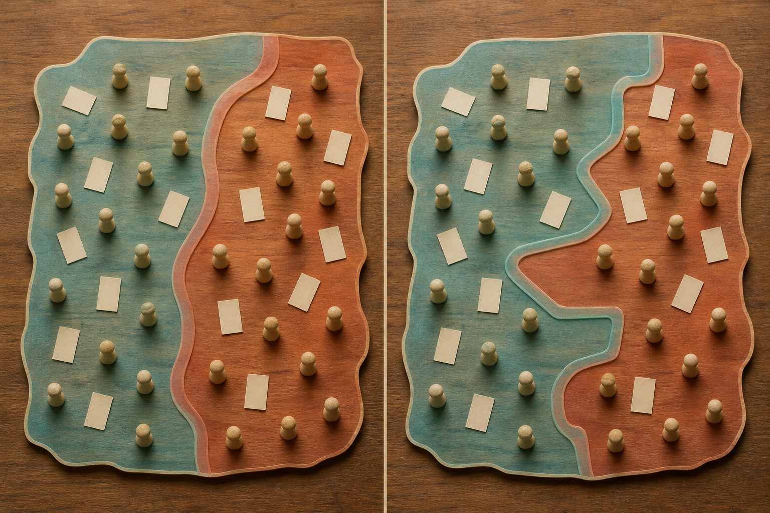
Election results depend on two things: how people vote and how those votes are grouped into constituencies. Delimitation changes the second. It does not add votes to a party, but it can change the efficiency with which an existing vote base produces victories.
Imagine that a party’s strongest wards are bundled into a small number of constituencies. It may win those seats by enormous margins while losing several neighbouring seats narrowly. If the same wards are distributed differently, the party may become competitive across more constituencies. The overall number of supporters has not changed; the conversion of support into seats has.
This is why the national argument over how many seats each state should receive is only one part of delimitation. Even when a state’s total number of seats remains fixed, internal boundary choices can affect representation. A serious assessment therefore separates three questions:
- Are constituencies reasonably balanced under the population rule governing the exercise?
- Were tehsils, municipalities, cities, districts and wards kept together wherever practical?
- Did the chosen arrangement concentrate or disperse identifiable voting blocs in a way that plausible alternatives would not?
Population balance is essential, but it is not a complete defence of a map. Several configurations may satisfy the same population target. The consequential decision is often which configuration the authority selects and why.
Maharashtra shows which boundary changes deserve an explanation

Maharashtra’s electoral boundaries were redrawn in February 2008 for the first time since 1976. That long interval made the exercise unusually consequential: voters, parties and candidates entered the next election under a substantially rearranged map.
The most important warning signs were not merely unusual-looking constituencies. The exercise divided 46 tehsils beyond what the population quota required and placed five wards of one city in the Lok Sabha constituency of another district. Such choices do not automatically establish manipulation, but they create a clear burden of explanation. If the required population balance could have been achieved while keeping more administrative units intact, the public should be shown why the more disruptive configuration was preferred.
One formerly marginal constituency also became the safest seat in Maharashtra as its occupant became Chief Minister. The coincidence warrants close examination. It does not, standing alone, prove intent. To move from suspicion to a defensible conclusion, you would need to compare the adopted boundary with feasible alternatives and transpose the same voting data onto each map.
The political context reinforces the need for that discipline. Maharashtra voted in October 2009, less than a year after the 26/11 attacks. The Congress-NCP government secured a third consecutive term amid an opposition divided by the MNS challenge to the Shiv Sena’s base and an unsuccessful BJP-Shiv Sena effort to convert public anger into a wider electoral victory. Boundary changes belonged in the analysis, but they were not the only variable.
That distinction matters whenever somebody claims a map “caused” an election result. Delimitation may change margins, convert close contests or concentrate support, but an election also reflects turnout, alliances, candidate selection, campaigns and changing voter preferences. Ask for a seat-by-seat counterfactual under the old and new boundaries. Do not accept either extreme: pretending the map was irrelevant or treating it as a complete explanation.
How to audit a delimitation proposal before accepting it

You do not need to be a cartographer to scrutinise delimitation. You need comparable data and a repeatable sequence. Apply the following checks in order so that party preference does not determine your conclusion before the evidence does.
- Define the decision being made. Separate the allocation of seats among states or regions from the drawing of boundaries inside a state. A proposal can be defensible at one level and weak at the other.
- Build an old-to-new crosswalk. For each constituency, list the tehsils, municipal areas and wards it loses or gains. This reveals the actual transfer of voters, which a state-level map can conceal.
- Check the population calculation consistently. Use the same controlling population dataset for every constituency, record each seat’s deviation from the target, and ask whether unusually large deviations have written explanations. Do not substitute the number of registered electors for the population measure; the two answer different questions.
- Mark every divided administrative unit. Splitting a tehsil, city or ward may sometimes be unavoidable, but each split should solve an identifiable population or geographic problem. A large cluster of unnecessary divisions is more significant than one awkward boundary viewed in isolation.
- Test geographic and civic coherence. Ask whether residents placed in the same constituency share practical administrative connections, whether detached fragments have been created, and whether crossing a district boundary was necessary. The relevant question is not whether a line looks elegant but whether the grouped areas form a workable representative unit.
- Run an electoral stress test. Where reliable booth- or ward-level results are available, apply the same past votes to both the old and proposed boundaries. Past votes do not predict the next election, but this exercise can show whether the new design systematically packs one party’s support into a few seats or spreads another party’s support across many competitive seats.
- Compare at least one feasible alternative. An objection becomes much stronger when it supplies another contiguous map that meets the same population constraint while dividing fewer administrative units. If the adopted plan remains superior, the authority should be able to explain the difference in public.
Keep the neutral tests separate from the political-impact test. Start with population, contiguity, administrative integrity and consistency. Only then examine who gains. If you begin with the beneficiary, you are likely to excuse an irregularity when your side benefits and condemn the same irregularity when it does not.
Fair reform requires regular correction and a visible audit trail

Waiting from 1976 to 2008 did not make Maharashtra’s eventual redrawing less political. Long gaps allow demographic and urban changes to accumulate behind static boundaries, making the eventual correction larger and more disruptive. More regular reviews can reduce that accumulated shock, but frequency alone cannot guarantee fairness.
A recurring exercise conducted through opaque choices merely creates recurring opportunities for controversy. The better standard is regular, rule-bound and reviewable delimitation. Before boundaries are finalised, the public record should provide:
- old and proposed maps detailed enough to identify every affected tehsil, municipality and ward;
- the population target, the figure for every proposed constituency and each deviation from that target;
- a complete list of divided administrative units, with a specific reason for every division;
- an old-to-new geographic crosswalk in a form citizens and independent analysts can examine;
- the alternatives received during consultation and written reasons for accepting or rejecting them; and
- enough time between publication and finalisation for objections to be evidence-based rather than ceremonial.
The ideal interval between reviews cannot be derived from Maharashtra’s experience alone. The sound principle is simpler: boundaries should not remain frozen so long that representation drifts far from the governing population rule, and revisions should not occur at the convenience of whichever party holds power. The schedule and criteria should be known in advance.
For a Dharmic civic culture, the test is whether a rule restrains the ruler as firmly as it restrains the rival. A fair delimitation system should survive a change of government without requiring its defenders to change their principles. Ask yourself whether you would accept the same population deviation, tehsil division or cross-district transfer if it benefited the party you oppose.
Key takeaways for citizens assessing a new electoral map
- Delimitation changes how votes are grouped, so it can alter the translation of public support into seats without changing anyone’s vote.
- Population balance is necessary but not sufficient; alternative maps may satisfy the same quota while producing very different political effects.
- A divided tehsil or cross-district transfer is a warning sign that requires an explanation, not automatic proof of wrongdoing.
- The proper test of political effect is a comparison using the same voting data under the old map, the adopted map and feasible alternatives.
- Regular redrawing is preferable to decades of inertia only when the timetable, criteria, maps, data and responses to objections are public.
- Apply the same standard when your preferred party benefits as when it loses.
When the next delimitation proposal reaches you, resist the rush to ask which party wins. First locate every administrative split, calculate each population deviation, trace where voters have moved and demand the rejected alternatives. Once those facts are visible, the political argument becomes testable rather than tribal.
References
