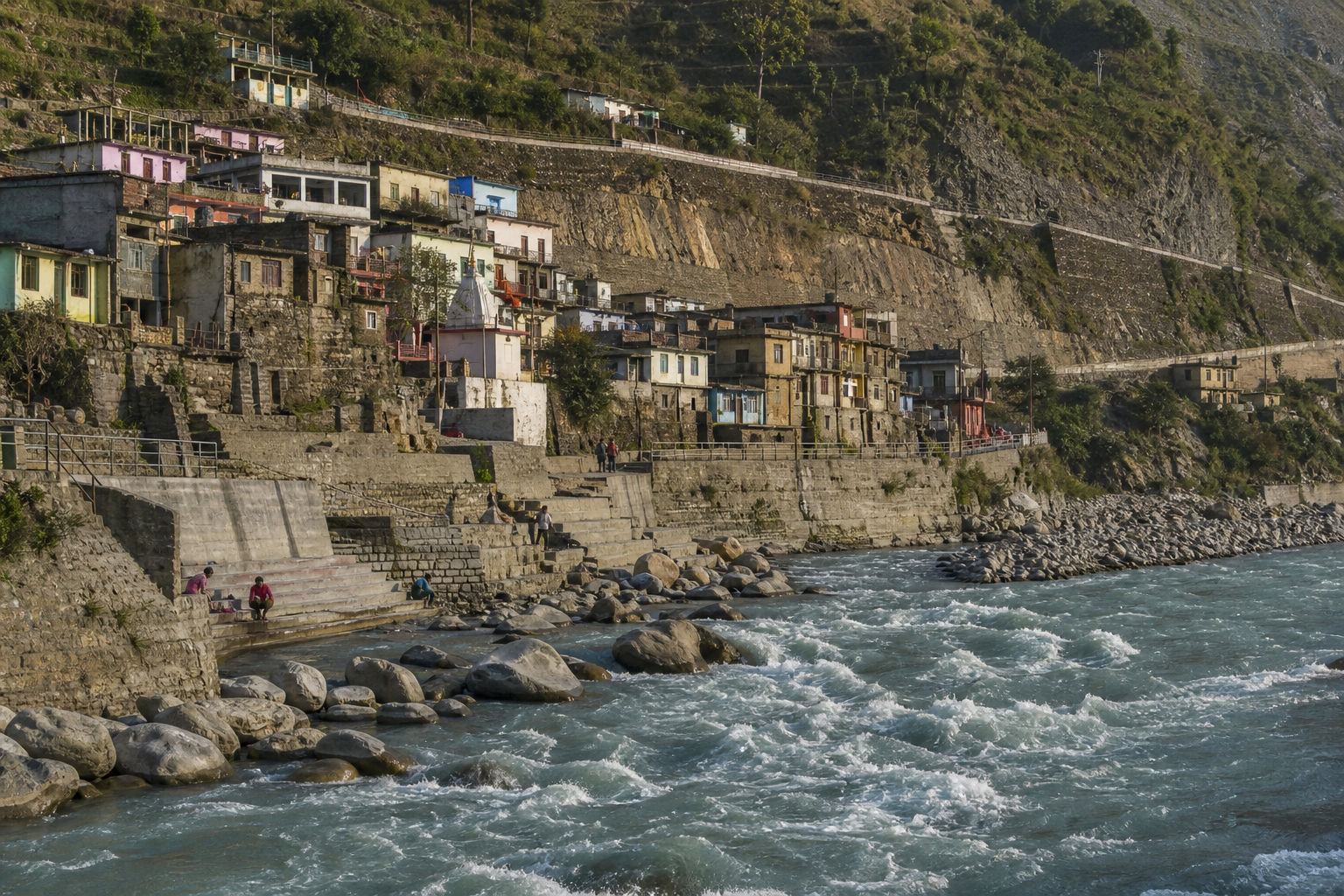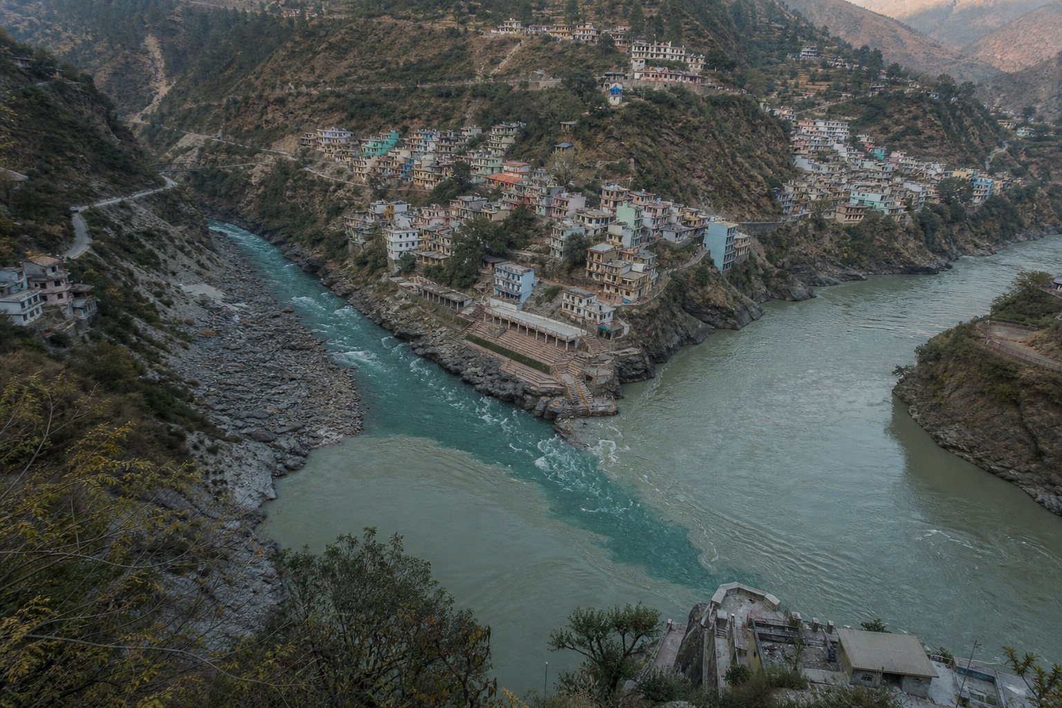
You may encounter Nandprayag as a name on the Badrinath road and wonder whether it deserves more than a brief halt. If you want to understand why a Himalayan river junction becomes a tirtha, stop here with enough attention to identify the waters, observe the rituals and notice how the landscape shapes both.
Nandprayag is not a monument that yields its meaning at a glance. Its significance lies in relationships: the Nandakini entering the Alaknanda, one prayag taking its place within a five-confluence route, and repeated acts of worship turning a dynamic riverbank into inherited sacred ground. Knowing how to read those relationships will make your visit more purposeful and safer.
Read the rivers before you read the legends
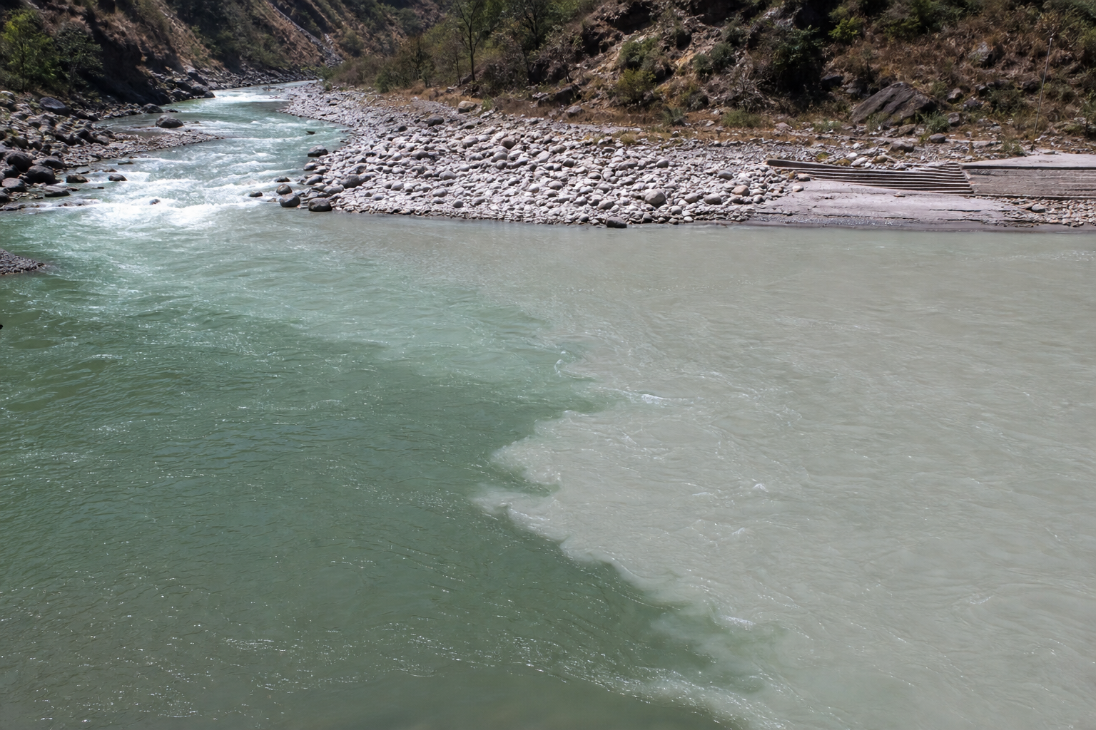
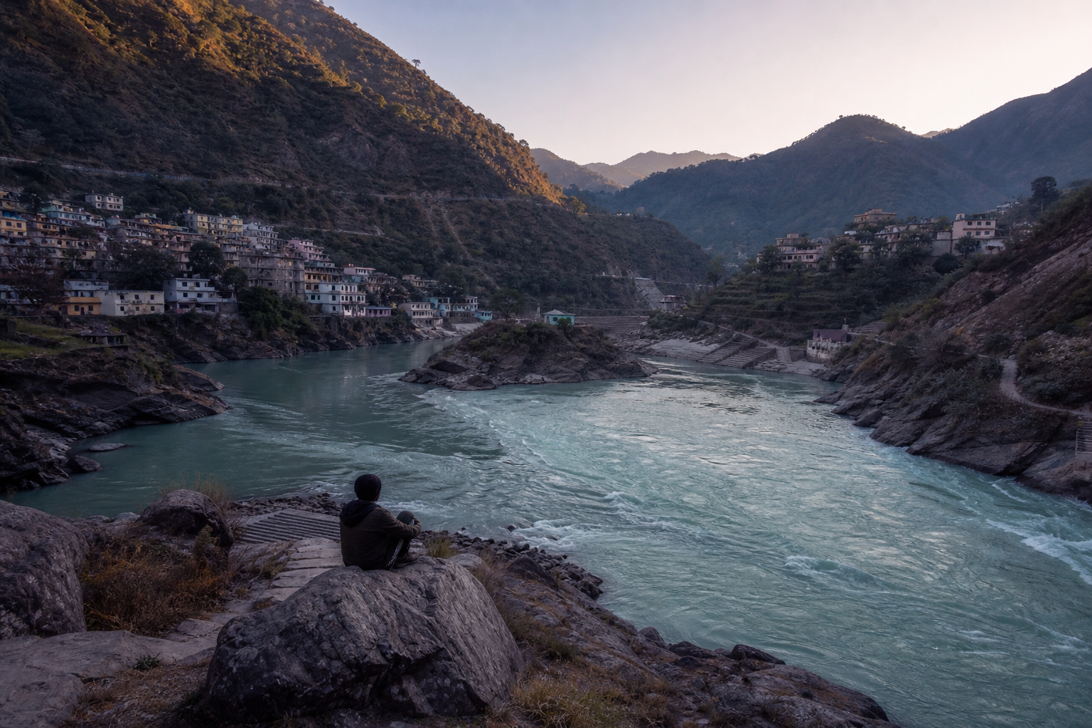
Nandprayag stands at approximately 1,358 metres in Uttarakhand’s Chamoli district. Here the Nandakini joins the Alaknanda, the major river around which the Panch Prayag sequence is organised. That simple identification matters: Nandprayag is the Alaknanda-Nandakini confluence, not the meeting of the Alaknanda and Mandakini.
The Nandakini descends from snowfields and small glaciers on the western side of the Nanda Devi-Nanda Ghunti-Trishul mountain system. It passes through the Nandakini Valley and Ghat before turning north towards Nandprayag. When you trace that path mentally, the tributary in front of you stops being an anonymous stream. It becomes a line connecting high snowfields, settlements, cultivated valleys and the Alaknanda corridor.
Begin your observation from a secure position on the established ghat. Identify the broader Alaknanda and then find the Nandakini entering it. Follow the visible seam downstream until the two waters become one channel. During the monsoon, the relatively clear, green-toned Nandakini can contrast with the more sediment-laden, grey Alaknanda. Treat this colour difference as a seasonal possibility, not a promised spectacle. High water may make it more apparent, but July and August also bring stronger discharge and greater landslide risk.
Look beyond colour. Higher seasonal flows can rearrange gravel, form lateral bars, expose older river terraces and create short braided reaches. Coarse material moving over the bed can sometimes be heard as water passes across the gneiss-and-schist setting of the Lesser Himalaya. These changes are part of the confluence’s meaning. Sacred continuity here does not depend on a motionless landscape; it is maintained beside a river system that continually reshapes its own banks.
Place Nandprayag correctly within Panch Prayag
Panch Prayag is best understood as an ordered river route rather than a loose collection of five holy places. Moving downstream along the Alaknanda system, Nandprayag is the second confluence from the sourceward end. The sequence culminates at Devprayag, where the meeting with the Bhagirathi receives the name Ganga.
| Order along the route | Prayag | Rivers meeting | What to remember |
|---|---|---|---|
| 1 | Vishnuprayag | Alaknanda and Dhauliganga | The sourceward confluence in the five-prayag sequence |
| 2 | Nandprayag | Alaknanda and Nandakini | The Nandakini Valley enters the Alaknanda corridor |
| 3 | Karnaprayag | Alaknanda and Pindar | The next confluence downstream |
| 4 | Rudraprayag | Alaknanda and Mandakini | Mandakini belongs here, not at Nandprayag |
| 5 | Devprayag | Alaknanda and Bhagirathi | The united river is named Ganga |
The Nandakini-Mandakini distinction is more than a spelling lesson. Each tributary carries a different valley into the Alaknanda and gives its prayag a distinct geographic identity. Confusing the names erases the very structure that the pilgrimage is meant to reveal.
If you travel through several prayags, use the table as an observation framework. At each stop, name the tributary, identify the direction from which it arrives and watch what happens after the meeting. The sequence then becomes a cumulative lesson: different mountain waters enter one expanding sacred river system before the name Ganga emerges at Devprayag.
See how repeated worship makes a living tirtha
Local memory associates the name Nandprayag with both King Nanda and the goddess Nanda Devi. Oral traditions recall yajnas on the banks and connect the confluence with the wider ethos of the Nanda Devi Raj Jaat, in which pilgrimage affirms mountains as divine presence as well as a shared community inheritance. These memories should be approached as living tradition rather than forced into a single, overly tidy origin story.
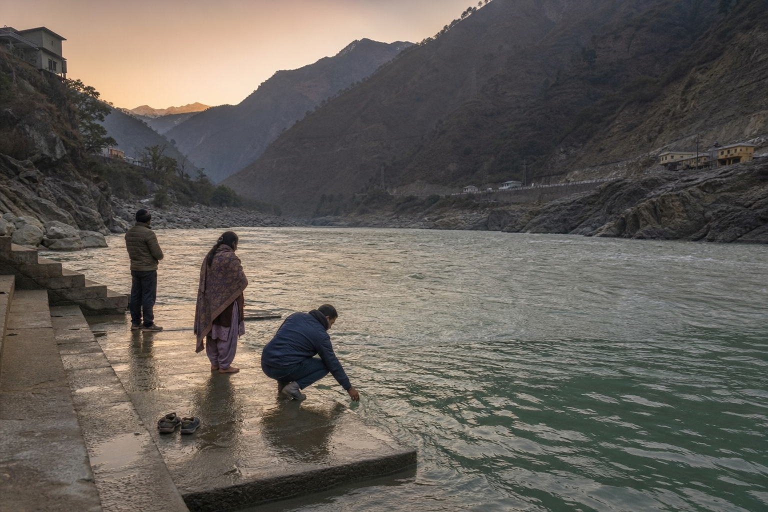
The daily life of the tirtha is easier to see through practice. Dawn is associated with tirtha-snan, the evening with sandhya aarti, and the ghats also serve families making offerings connected with pitri-tarpan. You do not need to perform every rite to understand the place. Watch how time, water and inherited forms of worship organise conduct around the confluence.
- If you intend to bathe, first ask where bathing is currently permitted. Use only designated, roped areas and follow local guidance.
- If you attend the evening aarti, arrive without treating it as a performance staged for travellers. Allow worshippers carrying out their observance the space they need.
- If you have come for pitri-tarpan but do not know the local procedure, ask a qualified local priest rather than improvising an offering at the water’s edge.
- If your visit falls around Kartika Purnima, Makar Sankranti or Mauni Amavasya, expect a stronger pilgrim presence and allow more room for ritual activity on the ghats.
Nandprayag also helps you recognise a wider dharmic pattern without pretending that every tradition is identical. Hindu, Buddhist, Jain and Sikh disciplines have their own theologies and pilgrimage forms, yet each preserves ways of treating water and the natural world as more than consumable scenery. Sikh devotion at Himalayan sanctuaries such as Hemkunt Sahib, Buddhist and Jain tirtha-yatras, and Hindu confluence worship differ in practice. Their shared ethical note is reverence, not sameness.
Use a field method that protects both you and the tirtha
A useful visit can combine pilgrimage with disciplined observation. The following order prevents the common mistake of descending immediately to the water without first reading the site.
- Orient yourself from above the ghat. Locate the two upstream channels, the meeting point and the single downstream channel before approaching the steps.
- Name what you see. The main stem is the Alaknanda; the tributary is the Nandakini. Repeat the distinction until you could explain it to another traveller without consulting a map.
- Notice the moving land. Look for sediment bars, exposed terraces, bends, bedrock and differences in water colour. Do not step onto a bar merely to obtain a better view; its accessibility can change with discharge.
- Observe the human rhythm. Notice when bathing, prayer, aarti, maintenance and ordinary movement occur. Sacred geography includes the people who repeatedly care for and use the ghat.
- Leave without adding a burden. Carry away single-use plastic, choose biodegradable ritual materials and keep detergents or soap out of the river.
The Alaknanda’s current becomes more forceful towards mid-channel. A calm-looking edge does not make the main flow safe, and spiritual intention does not remove physical danger. If local conditions do not permit bathing, remain on the ghat and offer prayer without entering the river. This is especially important during high discharge and the monsoon.
Responsible conduct is part of the pilgrimage, not an environmental extra added afterwards. An offering that introduces plastic, detergent or persistent waste contradicts the reverence it is meant to express. The practical test is simple: your worship should not leave the next pilgrim, the local community or downstream life to manage what you discarded.
FAQ: plan Nandprayag into your Himalayan journey
Which travel periods offer the best balance?
Late April through June and September through November generally offer clearer visibility and relatively more stable mountain-road conditions. July and August bring monsoon discharge and increased landslide risk. December through February can be cold, with occasional snowfall and reduced services. If seeing the confluence safely is your priority, do not choose the monsoon merely in pursuit of contrasting water colours.
Where does Nandprayag sit on the road route?
Nandprayag lies on National Highway 7, between Karnaprayag and Chamoli, and forms a natural stop on the route from Rishikesh towards Badrinath. The approximate road distances are 190 km from Rishikesh, 55 km from Rudraprayag, 22 km from Karnaprayag, 17 km from Chamoli and 108 km from Badrinath. Use those figures to understand the route, not to promise yourself an arrival time; mountain-road conditions can alter the day’s pace.
Public buses and shared taxis operate along the corridor. Yog Nagri Rishikesh is the nearest railhead identified for the journey, while Jolly Grant Airport in Dehradun is the nearest airport. Confirm operating times locally before committing to an onward connection, particularly outside the main pilgrimage periods.
How can you build a fuller sacred-geography itinerary?
If you are travelling towards Badrinath, Nandprayag can be paired naturally with Karnaprayag, Rudraprayag and Devprayag along the broader road corridor, followed by Vishnuprayag nearer Joshimath. Auli, Joshimath and the Valley of Flowers can extend the journey into the region’s wider cultural and ecological landscape. Keep the purpose clear: a Panch Prayag journey becomes meaningful when you identify each tributary and confluence, not when you merely collect five place names.
When you reach Nandprayag, begin with two names: Alaknanda and Nandakini. Find both waters, follow their meeting and let the conditions on the ghat determine whether your next act is prayer, aarti, quiet observation or onward travel. That small discipline turns a roadside stop into participation in a living sacred landscape.